


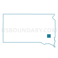
VTD-precinct 1, McCook County, South Dakota
About
Outline

Summary
| Unique Area Identifier | 667510 |
| Name | VTD-precinct 1 |
| County | McCook County |
| State | South Dakota |
| Area (square miles) | 107.93 |
| Land Area (square miles) | 106.66 |
| Water Area (square miles) | 1.27 |
| % of Land Area | 98.82 |
| % of Water Area | 1.18 |
| Latitude of the Internal Point | 43.72487550 |
| Longtitude of the Internal Point | -97.19936350 |
Maps

Graphs
Select a template below for downloading or customizing gragh for VTD-precinct 1, McCook County, South Dakota


Neighbors
Neighoring Voting District (by Name) Neighboring Voting District on the Map
- Chester-Franklin precinct, Lake County, SD
- Farmington-LeRoy-Clarno-Orland precinct, Lake County, SD
- VTD VP0-8, Minnehaha County, SD
- VTD VP13, Minnehaha County, SD
- VTD-precinct 3, McCook County, SD
- VTD-precinct 6, McCook County, SD
Top 10 Neighboring County Subdivision (by Population) Neighboring County Subdivision on the Map
- Montrose city, McCook County, SD (472)
- Humboldt township, Minnehaha County, SD (339)
- Spring Valley township, McCook County, SD (311)
- Franklin township, Lake County, SD (307)
- Wellington township, Minnehaha County, SD (277)
- Greenland township, McCook County, SD (251)
- Ramsey township, McCook County, SD (229)
- Buffalo township, Minnehaha County, SD (212)
- Montrose township, McCook County, SD (195)
- Clear Lake township, Minnehaha County, SD (191)
Top 10 Neighboring Place (by Population) Neighboring Place on the Map
Top 10 Neighboring Unified School District (by Population) Neighboring Unified School District on the Map
- Madison Central School District 39-2, SD (8,762)
- West Central School District 49-7, SD (6,058)
- McCook Central School District 43-7, SD (2,300)
- Chester School District 39-1, SD (1,692)
- Canistota School District 43-1, SD (1,207)
- Montrose School District 43-2, SD (1,120)
Top 10 Neighboring State Legislative District Lower Chamber (by Population) Neighboring State Legislative District Lower Chamber on the Map
Top 10 Neighboring State Legislative District Upper Chamber (by Population) Neighboring State Legislative District Upper Chamber on the Map
Top 10 Neighboring 111th Congressional District (by Population) Neighboring 111th Congressional District on the Map
Top 10 Neighboring Census Tract (by Population) Neighboring Census Tract on the Map
- Census Tract 103, Minnehaha County, SD (5,590)
- Census Tract 9646, McCook County, SD (3,213)
- Census Tract 102, Minnehaha County, SD (2,712)
- Census Tract 9647, McCook County, SD (2,405)
- Census Tract 9601, Lake County, SD (2,337)
- Census Tract 9603, Lake County, SD (2,253)
Top 10 Neighboring 5-Digit ZIP Code Tabulation Area (by Population) Neighboring 5-Digit ZIP Code Tabulation Area on the Map
- 57042, SD (8,415)
- 57058, SD (1,973)
- 57018, SD (1,372)
- 57035, SD (1,200)
- 57048, SD (1,170)
- 57012, SD (1,160)
- 57076, SD (521)